The settings in this topic are available only with the Capability property selection of Advanced Real-time Signal Generation found in the GNSS node. The trajectory generator capability requires the purchase of an advanced real-time option that includes the scenario generator.
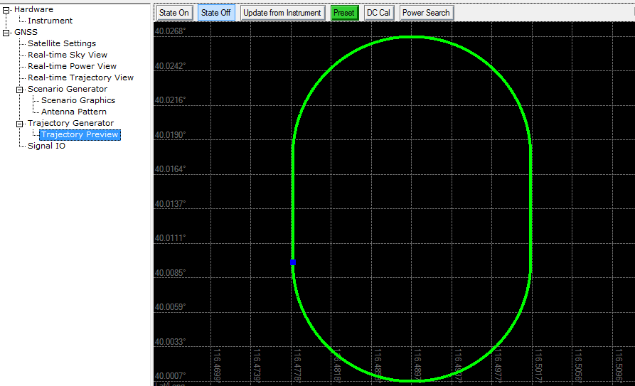
To view the results of the trajectory generator settings, use the ![]() Trajectory Preview node.
Trajectory Preview node.
Click this ![]() button to launch a dialog box to name
and save the current trajectory settings, which also includes the segment
settings. This does not save the trajectory for use with a scenario. To use the trajectory with a scenario, use the Export function.
button to launch a dialog box to name
and save the current trajectory settings, which also includes the segment
settings. This does not save the trajectory for use with a scenario. To use the trajectory with a scenario, use the Export function.
Click this ![]() button to launch a dialog box to load
a previously saved trajectory settings file, which also includes the segment
settings.
button to launch a dialog box to load
a previously saved trajectory settings file, which also includes the segment
settings.
Clicking this button displays a KML to NMEA Converter dialog box, asking you to select the KML files you've saved.
Choice: Wait | Straight | Turn
Add a single segment item to the trajectory table.
Remove a single segment item from the existing trajectory table.
Copy an existing segment item to the original trajectory table.
Move an existing segment item up in the original trajectory table.
Move an existing segment item down in the original trajectory table.
Delete all the existing segment items from the original trajectory table.
Choice: Rectangle | Circle
Click on and select either rectangle or circle to quickly generate a simple trajectory, which can be viewed in node.
Choice: Google Map html | Google Earth Kml | NMEA GGA
Once the trajectory has been defined, the path data can be saved as an NMEA GGA format file, a Google Map html file, or a Google Earth kml file, which could be utilized in different applications.
|
NMEA GGA |
Creates a file for use in the Scenario Generator. The Scenario Generator uses the NMEA GGA file when the Scenario Type is Dynamic. |
|
Google Map html |
Creates a trajectory file, that when double clicked, launches your web-browser that displays a picture of the coordinates with the overlay of the trajectory. |
|
Google Earth kml |
Creates a Google Earth file that when double-clicked, launches Google Earth. Google Earth use the data from the file to display the coordinates with the overlay of the trajectory. If needed, use the software's KML to NMEA Converter to convert the Google Earth kml file to an NMEA GGA file for use by the Scenario Generator. |
To view the Google Map html and Google Earth kml files, this requires the installation of Google Earth.
Enter the reference longitude of starting location of the trajectory in degrees. Enter a positive number for East and negative number for West or a positive number with W/E appended.
Enter the reference latitude of starting location of the trajectory in degrees. Enter a positive number for North and negative number for South or a positive number with N/S appended.
Range: -100 m - 10000 m
Default: 100 m
Enter the reference altitude in meters of starting location of the trajectory.
Range: 0 - 200 m/s
Default: 0.0 m/s
Enter the initial velocity of the moving GNSS receiver at the beginning of the trajectory in meter/second.
Range: 0 - 360°
Default: 0.0°
Enter the initial direction in azimuth degrees that the moving GNSS receiver is heading for at the beginning of the trajectory. 0° points to the north and azimuth increases along the clockwise direction.
Range: 0.1 - 20 Hz
Default: 1 Hz
Enter the sampling rate in Hz with which the trajectory is sampled. Higher sampling rate provides better fitting of the trajectory. Total sampling points of the trajectory will be the product of sampling rate and duration.
Range: 00:00:00 - 23:59:59
Default: 00:00:00
Enter the start time at the beginning of the trajectory. This time will appear in the first line of generated NMEA GGA file.
Choice: Duration | Distance
Default: Duration
Select the basis of segment length. Duration means that user defines the segment length by specifying its duration in seconds and distance is automatically calculated based on other settings. Distance mode defines segment length by specifying its distance in meters and duration is automatically calculated based on other settings.
Range: 1 - 100
Default: 1
Enter the number of times that the segments in the list will be repeated to form a longer trajectory. This function does not check to see if start and stop position of the trajectory path are the same, so if they are not, a jump will occur in the receiver’s position when the path is repeated. For a smooth trajectory, this function should only be used with a closed-loop trajectory path such as a circle or rectangle.
This column displays the segment type. Select the segment type using the Add button drop-down menu.
Coupling:
When this cell is changed, Distance and Ending Velocity will change accordingly.
Editable with only the and segment types.
Enter the duration in seconds of the segment.
The software automatically calculates the distance value using the following formulas:
segment type:
Distance = initial velocity x Duration + Accelerate x Duration2
Initial velocity is equal to the ending velocity of the previous segment, or if the first segment is a wait, then the initial velocity is the value entered into the Initial Velocity cell.
A change to any of the three values changes the distance value.
segment type:
Distance = Angle X Radius
Coupling:
Editable with only the segment types.
A change in this value also affects the values for and ), or a change in either of the other two values changes this value.
Enter the accelerate value in meters per second square of the segment.
Coupling:
Editable with only the and segment types.
A change in this value also affects the values for and 2) , or a change in either of the other two values changes this value.
Enter the ending velocity in meters per second.
For a Straight segment type: Ending Velocity = Initial velocity + Accelerate x Duration
Initial velocity is equal to the ending velocity of the previous segment, or if the first segment is a wait, then the initial velocity is the value entered into the Initial Velocity cell.
Coupling: Editable with only the Straight and Turn segment types.
Enter the Angle in degrees.
Coupling: Editable with only the Turn segment type.
Enter the Radius in meters.
Coupling: Editable with only the Straight and Turn segment types.
Enter the climb rate of the moving GPS receiver in m/s. This property will only affect the altitude.