GNSS Settings
Toolbar Functions
Parameters
Toolbar Functions
Pause/Resume
Default: Pause
Coupling: Active while playing
a scenario in Navigation mode.
When there is a need to pause the scenario rather then stopping and starting over, use these buttons. The Pause button pauses the scenario at its current file location, and upon clicking Resume, the scenario starts where it paused. The Pause and Resume buttons occupy the same space. When Pause is clicked, it changes to Resume. After Resume is clicked, it changes back to Pause.
Restart
Coupling: Active while playing
a scenario in Navigation mode.
Click the button to restart
the scenario (Navigation mode) or a static test (Static Test mode).
If a Scenario
Start Time Offset value is entered, the software restarts the scenario
at the entered offset time value. The progress bar also restarts from
the offset value.
Restart does not perform a power calibration. When modifying parameters that may affect the power level such as , it is recommended that you perform a power calibration to attain the proper test results. To perform a power calibration if the power calibration is set to , click , otherwise click the active button to perform a manual power calibration. For more information on power calibrations, refer to the PXB User Interface, Menu Bar descriptions.
Reset Channels
Coupling: Available only when the signal is not playing
Click the button
to reset the current satellite channel settings in the Satellite Settings node with the exception of the
column:
|
Navigation mode
|
Resets values according to the start record of the current scenario.
|
|
Static Test mode
|
Resets values to default settings. After starting the test, the software
updates the
column with values derived from the power calibration.
|
Disable UTC Display/Enable UTC Display
Default: Disable UTC Display
Coupling: Active while playing
a scenario in Navigation mode.
The Disable UTC Display and Enable UTC Display buttons occupy the same space. When Disable UTC Display is  clicked, it stops the progress bar from displaying any further progress and stops the scenario time counter located to the right of the progress bar. In addition the button name changes to Enable UTC Display. While the progress bar and scenario time counter stops, the scenario continues to play. When Enable UTC Display is clicked, the software updates the progress bar and scenario time counter to the current location in the scenario playback and the button name changes back to Disable UTC Display.
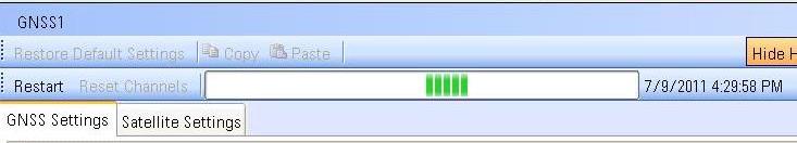
Scenario Started—Disable UTC Display Button Shows

Scenario Running—UTC Display Disabled

Scenario Running—UTC Display Enabled

Progress Bar
Coupling: Active while playing
a scenario in Navigation mode.
The Progress Bar shows the UTC time of Scenario playback and it displays in two different modes:

-
When using User Scenario Files, the progress bar shows the progress.
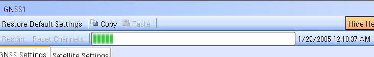
-
When the Signal Source is Scenario Generator Settings, that means real time generation, it shows as a bouncing bar.
Parameters
1. Capability
Capability
This read only property shows that the GNSS software is configured for advanced real-time signal generation.
2. General
Simulation Mode
Choice: Navigation |
Static Test
Default:
Navigation
Select the simulation mode of GNSS signal. Navigation mode will create satellites data or load it from a scenario file to simulate GNSS signal in a real world. Static Test mode simulates a static GNSS signal by configuring each satellite's properties.
|
Navigation
|
Simulates a real-world GNSS signal by reading the satellite data from
a scenario file. Within the Satellite Settings tab, you can deselect active
satellites and change the relative power between satellites while the
signal is playing.
|
|
Static Test
|
Simulate a static GNSS signal where the satellite channels and settings
are initialized by a scenario file, but do not change with time (as if the satellites were frozen in time). Within the tab, reconfigure the properties for
each active satellite initialized by the scenario file, and manually activate
and configure the properties for inactive satellites.
|
Choice: User Scenario File | Scenario Generator Settings
Default: User Scenario File
Select the type of scenario data source for playback.
User Scenario File indicates that it will load an existing scenario file for playback, while Scenario Generator Settings means that it will start a real-time scenario generation and playback based on the settings under Scenario Generator node.
Default: C:\Program Files\Agilent\PXB\Infrastructure\Applications\Gnss\Scenarios\20110709_Beijing.ags
Couplings:
-
In Navigation mode, this parameter is only visible when is User Scenario File, and the scenario information automatically updates after changing to a new scenario
file.
-
In Static Test mode,
the satellite channels initialize with the starting record in the scenario
file.
Select a scenario file for playback in Navigation
mode or to initialize satellite channels in Static Test mode. The Signal
Studio software comes with factory supplied scenario files. To create custom scenario files for playback selection, use the Scenario Generator.
Scenario Start Time Offset
Range: 0 - Duration of
scenario
Default: 0.0
Coupling: Available with
the selection in the cell.
Enter an offset value in seconds with resolution
of three seconds, which indicates the starting position of the scenario
playback.
When the Scenario Source selection is , a change to the offset does not provide an offset, but instead changes the Start Date Time (GPS Time) set in the Scenario Generator tab by the amount of the entered offset.
If the user modifies the value and applies the change by clicking the
Restart button, the elapsed scenario
run-time display may have an error of up to one second. The error, if
it occurs, is caused by the different clock rates between the clock for
the FPGA/DSP (generates the real-time signal) and the clock for the host
CPU that controls the display update. The amount of error depends upon
the point in the clock timing where the Restart occurs.
Satellite Power Control
Choices: Equal Power | Range Based
Default: Equal Power
Coupling: Available with
the selection in the cell.
Select the satellite power control mode for all satellites used in the scenario.
|
Equal Power
|
All satellites have the same power level.
|
|
Range Based
|
The power level of each satellite is calculated based on its pseudorange value.
|
3. Constellation Control
GPS Enabled
Choice: On | Off
Default: On
Enable or disable GPS constellation in currently playing scenario.
GLONASS Enabled
Choice: On | Off
Default: On
Enable or disable GLONASS constellation in currently playing scenario.
Galileo Enabled
Choice: On | Off
Default: On
Enable or disable Galileo constellation in currently playing scenario.
Beidou Enabled
Choice: On | Off
Default: On
Enable or disable Beidou constellation in currently playing scenario.
GPS Relative Power Scale
Range: -40 dB to 40.00 dB
Default: 0 dB
Enter the power offset of the GPS constellation, relative to the original power level in the scenario file. This will be applied to all GPS satellites in the scenario.
GLONASS Relative Power Scale
Range: -40 dB to 40.00 dB
Default: 0 dB
Enter the power offset of the GLONASS constellation, relative to the original power level in the scenario file. This will be applied to all GLONASS satellites in the scenario.
Galileo Relative Power Scale
Range: -40 dB to 40.00 dB
Default: 0 dB
Enter the power offset of the Galileo constellation, relative to the original power level in the scenario file. This will be applied to all Galileo satellites in the scenario.
Beidou Relative Power Scale
Range: -40 dB to 40.00 dB
Default: 0 dB
Enter the power offset of the Beidou constellation, relative to the original power level in the scenario file. This will be applied to all Beidou satellites in the scenario.
4. Scenario Information
Title
Couplings: This cell is only visible in the Navigation
mode and is User Scenario File.
This read-only cell displays the name of the current
scenario file less the extension ".ags".
Visible Satellites
Couplings: This cell is only visible in the Navigation
mode and is User Scenario File.
This read-only cell displays the SV IDs in view during
scenario playback. The software updates this information every second
during playback.
Initial Longitude
Couplings: This cell is only visible in the Navigation
mode and is User Scenario File.
This read-only cell displays the initial longitude
in degrees of the selected scenario and updates with a change in scenario
file.
Initial Latitude
Couplings: This cell is only visible in the Navigation
mode and is User Scenario File.
This read-only cell displays the initial latitude
in degrees of the selected scenario and updates with a change in scenario
file.
Initial Altitude
Couplings: This cell is only visible in the Navigation
mode and is User Scenario File.
This read-only cell displays the initial altitude
in meters of the selected scenario and updates with a change in scenario
file.
Start Date Time
Couplings: This cell is only visible in the Navigation
mode and is User Scenario File.
This read-only cell displays the simulated date and
time of the selected scenario and updates with a change in scenario file.
Duration
Couplings: This cell is only visible in the Navigation
mode and is User Scenario File.
This read-only cell displays the duration of the
selected scenario in <HH:mm:ss> format and updates with a change
in scenario file.