This procedure guides you through the settings to generate a real-time GNSS signal using the , and the Signal IO on the software's user interface (UI).
To learn more about individual cell settings, refer to the UI descriptions.
While the scenario is playing, the GNSS node Constellation Control properties, and the properties under the Satellite Settings node are still active. These properties can be modified while the scenario is playing and affects the scenario in real-time. The GNSS Scenario Start Time Offset property is also still active, but will not affect the scenario unless it is paused and the Restart button is clicked.
In the tree, click to see the GNSS settings.
View the cell and ensure that is the current selection. If not, click the cell, and use the drop-down arrow to display a menu from which you can select .
View the cell and ensure that is the current selection. If not, click the cell, and use the drop-down arrow to display a menu from which you can select .
The selection enables a static GNSS signal that uses the scenario file to initialize the satellites. The user can then select the node to reconfigure the satellite properties to match the test needs.
Click the cell and ensure that is the current selection. If not, use the drop-down arrow menu to select .
The setting is available with only the Simulation Mode.
Click the cell and use the dialog box launch icon to launch the dialog box to navigate to and select a scenario file.
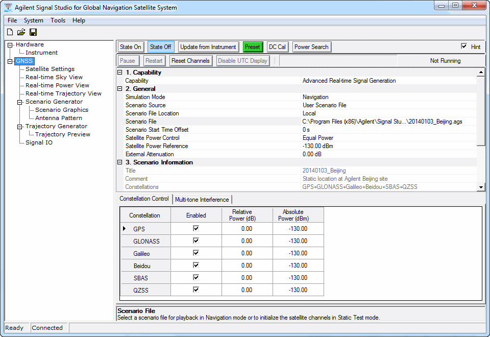
The default scenario file is 20130103_Beijing.ags, which is a GPS+GLONASS + Galileo + Beidou+QZSS+SBAS scenario file. For information on the factory supplied scenario files and to see which files support a particular GNSS constellation, see the "Factory Supplied GNSS Files" topic.
The factory supplied scenario files are located at the following path: "C:\<Program Files> or <Program Files (x86)>\Keysight\Signal Studio\Global Navigation Satellite System\Applications\Gnss\Scenarios".
After loading a file, the scenario information appears in the section of the GNSS Settings node (current selection).
Each constellation type requires a separate advanced license. When using a scenario file with multiple constellations, only those constellations that are licensed can be enabled.
Enter the , with the resolution of three seconds.
The start time offset indicates the starting position of scenario playback.
You can change the Start Time Offset during playback without stopping/restarting the scenario, but the change will have no effect until you stop the scenario and click either Restart.or .
is available only when is set to .
Select the Satellite Power Control method for either equal power among all satellites, or the power of each satellite is based on its pseudorange.
If the scenario file is using multiple constellations and there is a need to modify whether to transmit all constellations, or to add a power offset to the constellations, perform these setting either before playing the scenario or in real-time during the scenario file playback:
Typically these settings are used for constellation control during scenario playback.
Set each of the constellation type enabled cell, such as ,select either (default) or .
If more than one constellation is enabled, this means that you will be transmitting a combined signal.
Enter a power offset value in the constellation's relative power scale cell, such as GPS Relative Power Scale.
The power offset is set relative to the original power setting in the scenario file and is applied to all satellites for the constellation.
If there is a need for marker signals:
Click the Signal IO node.
Set each of the markers and the marker delay as needed.
In the Signal Generator view:
Set the frequency.
The software automatically sets the frequency to 1.57542 GHz. This frequency should be used even with GLONASS and Beidou because the software automatically offsets the signals in baseband to provide the correct RF frequencies for those GNSS signals.
Set any other needed parameters.
Click to start the playback from the beginning of the scenario or from the , if one is entered.
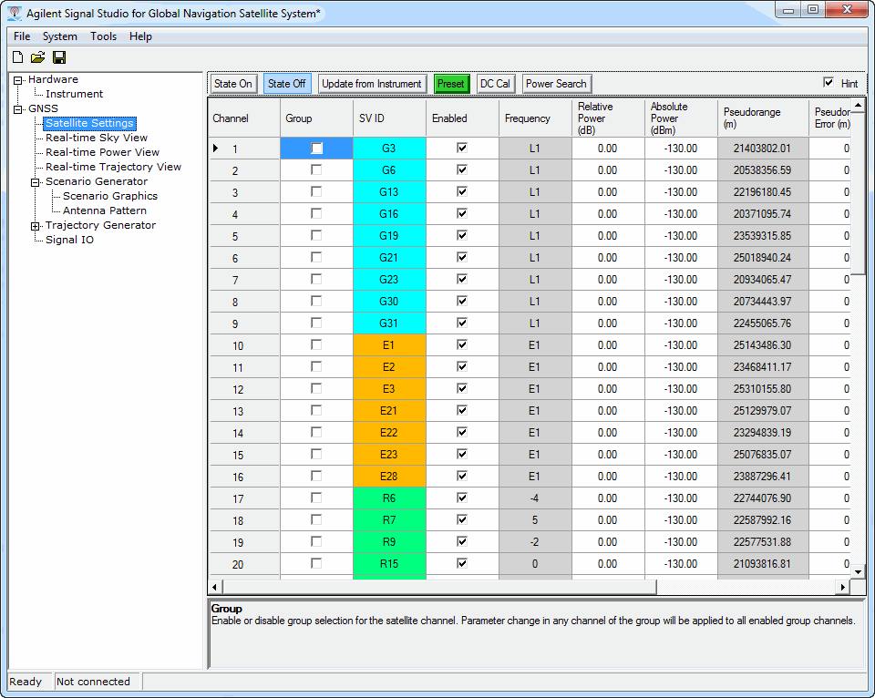
After the scenario is running on the signal generator,click the node to set various satellite parameters such as turning individual channels off or on in real-time
while the signal is playing. To change a channel’s status, click on the cell  .
.
Another setting to change in real-time is the relative power level for each satellite channel.
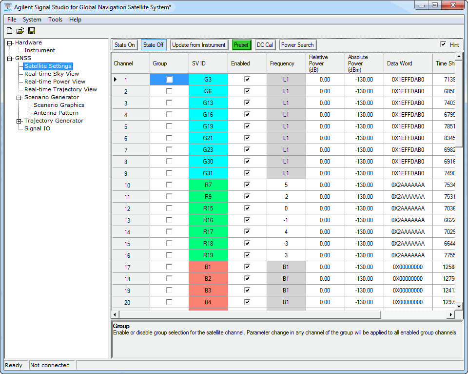
The available satellite settings vary depending on whether the Simulation Mode in the node is set to  Navigation or Static Test .
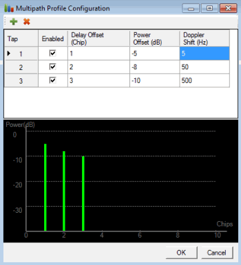
The mode of Satellite Settings includes a multipath setting for each satellite. It is accessed by clicking the button, which launches the dialog box. Setting the multipaths can also be done in real-time while the scenario is running. After setting the paths, the multipath channels are appended to the end of the satellite list with an asterisk next to the satellite designation.
Each constellation type uses a different SV ID designations that includes a letter and color for the satellites. In Navigation mode, the SV ID is set by the scenario file. In Static Test mode, you can assign SV IDs as needed.